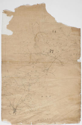
Map of Parsonstown (Birr) area
- IE OH OHS 86/1
- Item
- c.1808
Parte de Sketch maps of William Larkin
984 resultados com objetos digitais Mostrar resultados com objetos digitais
Map of Parsonstown (Birr) area
Parte de Sketch maps of William Larkin
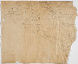
Parte de Sketch maps of William Larkin

Parte de Sketch maps of William Larkin
Leases of premises on the road to Burkeshill or adjoining Burkeshill
Parte de The Rosse Papers
Envelope of leases of premises which are all described as being on the road to Burkeshill or as adjoining Burkeshill, and have no other intelligible indication of location. [In date order.]
Leases of Clonivoe and other parts of the Sprigge estate in the barony of Coolestown
Parte de The Rosse Papers
Envelope of leases of Clonivoe and other parts of the Sprigge estate in the barony of Coolestown. [In date order.]
Lease of Ballyduff to William Southern
Parte de Geashill Estate Papers
Lease of part of the lands of Ballyduff from Edward Earl Digby to William Southern, at the yearly rate of £59-12-10.
Including 'A map of part Ballyduff containing 59.2.23 Plantation measure. Part of the Estate of The Right Honourable Earl of Digby in the Barony of Geashill and King's County. Layed down by a scale of 20 Perches in one Inch in February 1800 by Michael Cuddehy', hand coloured.
Lease of Dalgan and Ballydownan to William Digby
Parte de Geashill Estate Papers
Lease of part of the lands of Dalgan and Ballydownan from Edward Earl Digby to the Reverend William Digby, Dean of Clonfort, for three lives from 25 March 1800, at a yearly rate of £20-13-0.
Lease of Clonad and Gorteen to Daniel Delany
Parte de Geashill Estate Papers
Lease of part of the lands of Clonad and Gorteen from Edward Earl Digby to Daniel Delany, at the yearly rate of £13-10.
Parte de Geashill Estate Papers
'A map of part Dolgan [Dalgan] and Part Ballydoonan [Ballydownan] containing 21.2.25 plantation measure. Part of the Estate of The Right Honorable Earl of Digby situate in the Barony of Geashill and KIngs County laid down by a scale of 20 perches in one inch and copied in December 1799 by Michael Cuddehy'.
Digby Estate Valuation and Survey
Survey and valuation of the Digby estate completed by Michael Cuddehy, land surveyor, for Lord Digby, on 3 January 1798 and a further valuation on 25 June 1799 listing lands in the barony of Geashill that are out of lease. Townlands surveyed in the initial valuation are listed in Cuddehy's accompanying note as Annaharvey, Ballymooney, Ballyknockan, Ballycue and Ballyduff, although only those of Ballycue and Ballyduff are extant. The valuation is tabular, listing tenants' names, a description of their holdings (e.g. 'moory pasture', 'oat field', 'big fallow field' etc.), a measurement in A.R.P (acres, roods, perches) and a yearly value.
The second list entitled 'Lands in the Barony of Geashill out of lease except the parts disposed of as herein 25 June 1799' contain a list of the townlands Annaharvey, Ballymooney, Ballycue, Bluebell, Ballyduff , Dalgan, Ballydownan, Curragh, Killellery, Ballyavill, Cappincur, Kinockballyboy, Ballinagar, Killleigh, Scrub, Killeenmore, and Killurin. Each description is accompanied by a reference number for a map by Cuddehy which is not extant. There are also comments by Cuddehy on certain plots such as 'Darby Smollen declared tenant' in respect of a plot in Ballydownan and he notes that Cuddehy himself is proposed for a plot in Ballymooney of 149 acres.
Digby, Family of the Barons