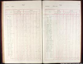
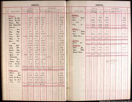
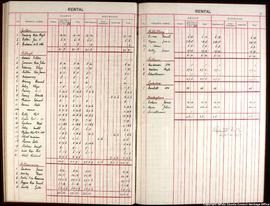
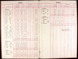
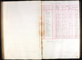
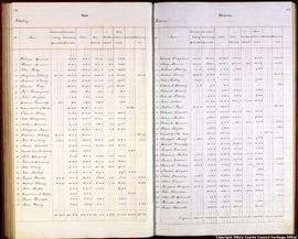
Elements area
Taxonomy
Code
Scope note(s)
Source note(s)
Display note(s)
Hierarchical terms
Killurin
Killurin
Equivalent terms
Killurin
- UF Killurine
This website uses cookies to track the amount of users to our site. This is achieved through third party metrics (Google Analytics) More info : https://www.offalyarchives.com/index.php/privacy
Copy of Ordnance Survey sheet 24 map of the Digby Estate issued by mapping department of the Irish Land Commission. Map
shows the holdings of tenant, Eliza Dunne in the townland of Killurin.
Scale - six inches to one statute mile.
Lease of part of the lands of Killurin from Edward Earl Digby to Thomas Scully for one life, or twenty-one years from 25 March 1825, at the yearly rate of £5-0-9.
Lease of part of the lands of Killurin from Edward Earl Digby to Widow Sarah Lynam for one life, or twenty-one years from 25 March 1825, at the yearly rate of £9-10-0.
Including 'A map of part of the lands of Killurin in the Barony of Geashill and King's County. Part of the Estate of the Right Honourable Earl Digby. Surveyed by John Molloy 1821', hand coloured, scale 20 Perches to an Inch, with bordering land leased to John Conner, Roger Quinlan, Widow Quinlan and Reverend Sadler.
Lease of part of the lands of Killurin from Edward Earl Digby to Widow Mahon for one life, or twenty-one years from 25 March 1825, at the yearly rate of £32-0-0.
Including 'A map of part of the lands of Killurin in the Barony of Geashill and King's County. Part of the Estate of the Right Honourable Earl Digby. Surveyed by John Molloy 1821', hand coloured, scale 20 Perches to an Inch, with bordering land leased to Charles Carroll, Mr Codd., David Brereton, Mr Suderon and Bennett and Quarter.
Also including a letter entitled ‘Planting notice’ from James Mahon addressed to George Thompson Esq., The Castle, Geashill, Agent of Earl Digby. Stating the intention to register his over 8000 trees planted in Killurin at the next Tullamore session.