Identity area
Reference code
Title
Date(s)
- 1839-1861 (Creation)
Level of description
Extent and medium
7 items
Context area
Name of creator
Repository
Archival history
Content and structure area
Scope and content
Series of hand drawn surveys of the lands at Tullabeg. Documents are pasted together and both sides are used. Area measured in Irish acres. Envelope in which contained indicates - ‘for Fr Eugene Browne SJ Milltown Park from Edmund Hogan SJ Survey of Tullabeg SJ by Fr John Grene SJ’.
-
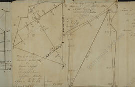
1858; 1861
Lawn surveyed by John Rorke, Luke J. Healy and John Sutton (12 - 14 May 1858); James Brady, Michael Higgins, Thomas Shannon and Daniel O’ Connell (16 - 19 April 1861); Connolly’s Holdings surveyed by James Brady, O’ Hanlon and John O’ Keefe (2 May 1861); Pond field surveyed by Alfred Coppinger, James Cohen, Laurence Robins, Joseph Ward and John O’ Keefe (7 - 8 May 18).
42 x 19 cms -
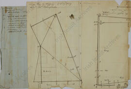
1857; 1858
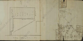
Tullabeg lawn surveyed by James Murphy, James McGrain, James Healy, Darby Kelly, Bern. McGrath, Pat Leahy and John McDermott (14 - 15 May 1857); Garden surveyed by William Joyce, Francis Curtain and John Rorke (5 November 1857); Hugh Morris’ Holding, a field adjoining the road and Grennan’s farm, on river side of road, surveyed by Anthony Geran, Edward Geran and James Dwyer (19 November 1857); Corcoran’s Farm surveyed by John Flynn, Joseph [ ]ooloughan, James Brady and James Dwyer (16 - 17 April 1858);
18 x 22 cms -
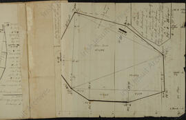
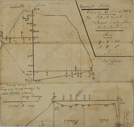
1858; 1859
Sandpit field surveyed by Patrick Lynch, Joseph [ ] ooloughan and Michael Dineen (23 March 1858); Quarry field surveyed by H. Nugent, P. Lynch, A. Lynch and Joseph [ ]ooloughan (18 March 1858) and Thomas Burke, John Barry and James Brady (24 June 1858); Paddock W[est] of chapel surveyed by John Sutton, John Star and Fra. M. Downing (19 May 1859).
18 x 17 cms -
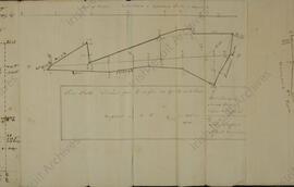
1857; 1859
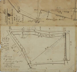
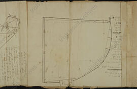
‘Plan of the Lawn of St. Stanislaus’ (Tullabeg) surveyed (14 - 15 May 1857); ‘College Bog by Stepping’ (17 July 1859). Scale - 10 chains to the Inch.
27 x 18 cms -
1839; 1845; 1859; 1861
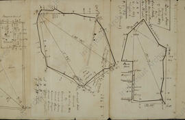
‘The Old Lake at Ballinlough as traced out on the Lawn’ (27 - 28 June 1859) and then surveyed by Edw. Cahill, Edw. Moran, John Nugent, James Nugent, James Brady, Alfred Coppinger and Edward McBarna; survey of Tullabeg exclusive of off-set by Peter O’ Connor, Daniel Parsons, Anthony Gallagher and Anthony Butler (17 - 20 June 1845) - ‘On 21 June 1834, the hour being found by observation of the sun’s altitude…a slate dial plate duly marked previously, was set up at noon, in the central flower plot of the Garden at Tullabeg + firmly screwed to a wooden column by Br. William Gaffney S.J.’; lawn surveyed by James Brady, Michael Higgins, Thomas Shannon and Dan O’ (16 and 19 April 1861); Connolly’s Holdings surveyed by James Brady, James O’ Hanlon, Charles Murphy and John O’ Keefe (3 - 4 May 1861); Rahan Convent Grounds surveyed by Edward Morrough Bernard, George Walsh and Richard Walsh (13 - 14 June 1839).
24 x 85 cms -
1841; 1845; 1860;
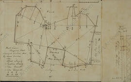
‘St. Stanislaus College - field on the river above the bridge’ surveyed by Charles McCabe, Thomas Shannon and James Dunne and 922 May 1860); ‘field of Clongowes S. of East Wood – Old play Ground field’ surveyed by William Seaver, Alfred Murphy, John Dunbar, Walter Rorke, Charles Dignan and Pat Kennedy (8 June 1845) and ‘South field beyond Old Play Ground (Clongowes ) S. of present Pl[ay] Gr[oun]d surveyed by John Cullen, William Seaver, Charles Coyne and John Dunbar (May 1841); ‘St. Stanislaus Lawn’ surveyed by Andrew Lynch, George Kelly and John Ingham (15 May 1860); ‘Field E.[ast] of Lawn’ surveyed by Philipo McNamara, James Ryan and Francis Fitzsimon (19 April 1859); ‘East Dock Galway’ (16 August 1859)
77 x 18 cms -
1844 - 1860
Western sector of Sand-pit field (11, 12, 25, 26 May 1859; 5 July 1860)
Field between Back Avenue and lawn (24 - 25 May 1859)
Lawn (15 - 17 July 1844; 12 - 14 May 1858; 7, 8 June 1859; 3 June 1860)
Lodge Field (31 May 1859)
Pleasure Ground (30 May, 23 June 1859)
Rahan Lodge Grounds (13 -14 June 1859)
Convent Cemetery Killina (2 February 1847)
Field South of Convent Garden (13 - 14 June 1859)
Two fields North of Killina Convent (1 June 1859)
Large Clump (8 July 1859)
Bog E. of Clara Road (7 July 1859)
River Field East (14, 19, 26 June 1860)
Paddock W. of chapel (13 April 1858)
Pond Field (23, 26, 27 April 1858)
House Quarter (20 April 1858)
Back Lawn - Clongowes Wood College (18 June 1841)
College Bog W. of Clara Road (12- 14 July 1859)
Field East of Garden (10 November 1857)
Field close to west of chapel (12 November 1857)
Quarry Field (7 May 1859)
Space between Plantation Wall and old Channel of the Clodagh West of Rahan Bridge (19 July 1860)
267 x 18cms
Appraisal, destruction and scheduling
Accruals
System of arrangement
Conditions of access and use area
Conditions governing access
Conditions governing reproduction
Language of material
Script of material
Language and script notes
Physical characteristics and technical requirements
Finding aids
Allied materials area
Existence and location of originals
Existence and location of copies
Related units of description
Notes area
Alternative identifier(s)
Access points
Subject access points
Place access points
Name access points
- St Stanislaus College, Tullabeg (Subject)
- Hogan; Edmund (1831-1917); Jesuit priest (Subject)
- Browne; Eugene (1823-1916); Jesuit priest (Subject)
- Grene, John (1807-1877); Jesuit priest and archivist (Subject)