
Identificatie
referentie code
Titel
Datum(s)
- c.1818 (Vervaardig)
- c.1808 (Vervaardig)
Beschrijvingsniveau
Omvang en medium
4 sheets
Context
Naam van de archiefvormer
Biografie
William Larkin was a land surveyor, notable for creating county maps in the early nineteenth century. Not much is known about him, other than that he attended the Dublin Society’s drawing school in 1788. He was most prolific in the early 1800s when he created a series of remarkable maps, beginning with 1805 map of the post roads of Ireland (British Library Maps 10835 (2)). He followed with road surveys for the Post Office such as Dublin – Enniskillen (1806), Dublin – Ratoath and Curragha (1807), and several other routes which saw him work across a large part of southern and western Ireland (1807-1808). 1807 also saw him complete a set of estate maps for the earl of Leitrim’s Manorhamilton estate.
Aorund this time, Larkin began to produce county maps, beginning with County Westmeath. Between 1817- 1819 he had published Meath, Waterford, Galway, Leitrim and Sligo. He had also had drafted manuscript maps for Cavan, Louth, Monagahn and King’s County.
The map for King’s County was completed in 1807 for the Grand Jury for their rooms at Philipstown (now Daingean). The map was never engraved or published due to a lack of subscribers. The manuscript map is now presumed lost.
In 1809, however, the newly constituted Bogs Commissioners engaged Larkin to produce a map of King’s County exhibiting all the bogs of the county. This was based on the manuscript county map and is now held by the National Archives of Ireland.
Larkin died some time before 1824.
archiefbewaarplaats
Geschiedenis van het archief
Donated by George Gossip to Offaly History in 2021.
Inhoud en structuur
Bereik en inhoud
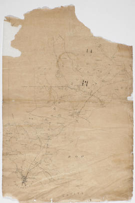
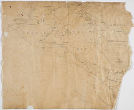
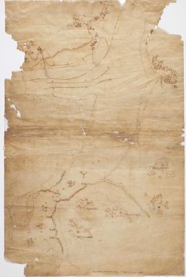
Three fragmentary draft or sketch maps on tracing paper of south and west Offaly dating to c.1808, and a fourth of the King's Channel area , County Waterford, dating possibly to Larkin's survey of County Waterford in 1818.
Waardering, vernietiging en slectie
Aanvullingen
Ordeningstelsel
Voorwaarden voor toegang en gebruik
Voorwaarden voor raadpleging
Available in digital surrogate only. Please click on an image above to download the digital file.
Voorwaarden voor reproductie
Taal van het materiaal
Schrift van het materiaal
Taal en schrift aantekeningen
Fysieke eigenschappen en technische eisen
Fragile works which were brittle and creased on acquisition in 2021. Underwent professional conservation in 2022 supported by the Heritage Council Capacity Fund.
Toegangen
Verwante materialen
Bestaan en verblifplaats van originelen
'A map of part of the Bogs of Allen within the King's County in Ireland together with Adjacent Country from actual survey', by Wiliam Larkin, available at the National Archives of Ireland: https://www.nationalarchives.ie/search-the-online-catalogue/advanced-search/#!/details/110030113
Grand Jury maps of Meath and Galway by William Larkin , courtesy of the L Brown Collection, available on Beyond2022: https://beyond2022.ie/mirador/grand-jury.html
Grand Jury map of Waterford by William Larkin available at Waterford City and County Archives and Waterford Museum.
Grand Jury maps of Westmeath, Sligo, and Leitrim by William Larkin available at the British Library.
Bestaan en verblijfplaats van kopieën
Related units of description
Notitie Publicaties
Arnold Horner, 'Mapping Offaly in the early 19th century' with an atlas of William Larkin's map of King's County, 1809', Wordwell (2006)